
Harveys Hideaway and the Isle of Wight
Places to Visit
Amazon World Zoo
Watery LaneIsle of Wight Zoo
Yaverland RoadAlum Bay
Robin Hill
Downend RoadWest Wight Alpacas & Llamas
Main RoadEmergency
St. Helens Medical Centre
Upper Green RoadBoots
3 High StEssentials
Tesco Extra
Brading RoadDog Friendly
Dogs are allowed on the beach between the sailing club and Culver Down head. On the rest of the beach dogs are not permitted from 1 May to 30 September. This does not include registered assistance dogs.
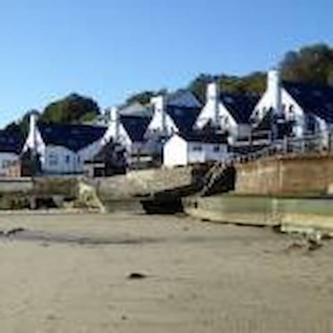
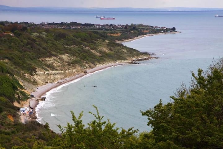
Located between Sandown and the cliffs of Culver Down, Yaverland is thought by many to be one of the best beaches on the Isle of Wight. The trick is to get here at low tide - at high tide there is only a relatively small section of sandy beach backed by sea-defences and an esplanade.
When the tide is out an enormous stretch of flat sand is exposed, leading to a section backed by sandy-hued cliffs. The beach has spectacular views across to the white chalk cliffs of Culver Down, jutting out into the English Channel.
Thrill-seekers are well catered for here. The Yaverland Sailing and Yacht Club has its home here, and the beach is used for jet-skiing, windsurfing, kitesurfing and other watersports. The beach is also popular with families, being quieter than most of the beaches between Sandown and Shanklin. The swimming areas of the beach are sectioned off from the watersport areas, although there is no lifeguard.
The cliffs along this stretch of the coast contain numerous fossils and there is a dinosaur museum - “Dino Isle”. Not far from the beach they run regular organised fossil-hunting trips. Visitors walking near the cliffs need to exercise caution because of the risks posed by falling rocks, and the possibility of incoming tides. (Take note of the safety signage)
The car park adjacent to the beach has parking spaces for 121 cars as well as having 6 disabled parking spaces. The toilet block here is eco-friendly, being powered by solar panels and wind turbines. There is also a beach shop and café here with outdoor seating.
Access to the beach is via a slipway next to the sailing club.
During the summer season, litter is collected daily from this beach. At some times of year a large amount of seaweed washes up here, although this is removed and used by local farmers as a fertiliser.
16 Einheimische empfehlen
Yaverland Beach
Dogs are allowed on the beach between the sailing club and Culver Down head. On the rest of the beach dogs are not permitted from 1 May to 30 September. This does not include registered assistance dogs.
Located between Sandown and the cliffs of Culver Down, Yaverland is thought by many to be one of the best beaches on the Isle of Wight. The trick is to get here at low tide - at high tide there is only a relatively small section of sandy beach backed by sea-defences and an esplanade.
When the tide is out an enormous stretch of flat sand is exposed, leading to a section backed by sandy-hued cliffs. The beach has spectacular views across to the white chalk cliffs of Culver Down, jutting out into the English Channel.
Thrill-seekers are well catered for here. The Yaverland Sailing and Yacht Club has its home here, and the beach is used for jet-skiing, windsurfing, kitesurfing and other watersports. The beach is also popular with families, being quieter than most of the beaches between Sandown and Shanklin. The swimming areas of the beach are sectioned off from the watersport areas, although there is no lifeguard.
The cliffs along this stretch of the coast contain numerous fossils and there is a dinosaur museum - “Dino Isle”. Not far from the beach they run regular organised fossil-hunting trips. Visitors walking near the cliffs need to exercise caution because of the risks posed by falling rocks, and the possibility of incoming tides. (Take note of the safety signage)
The car park adjacent to the beach has parking spaces for 121 cars as well as having 6 disabled parking spaces. The toilet block here is eco-friendly, being powered by solar panels and wind turbines. There is also a beach shop and café here with outdoor seating.
Access to the beach is via a slipway next to the sailing club.
During the summer season, litter is collected daily from this beach. At some times of year a large amount of seaweed washes up here, although this is removed and used by local farmers as a fertiliser.
The Isle of Wight Steam Railway is a heritage railway on the Isle of Wight. The railway passes through 5+1⁄2 miles (9 km) of countryside from Smallbrook Junction to Wootton station, passing through the small village of Havenstreet, where the line has a station, headquarters and a depot. At Smallbrook
Junction, the steam railway connects with the Island Line.
The first railway on the Isle of Wight opened in 1862, linking Newport and Cowes. It became the nucleus of the Isle of Wight Central Railway. The line from Ryde to Newport was opened in 1875 and by 1890 the island was served by an extensive network of lines. However most of these lines were relatively poorly maintained and had a low level of traffic, reflecting the general isolation and poverty of the island.
These factors meant that the island's railways could rarely afford to acquire new locomotives or rolling stock and instead relied on using already elderly equipment transferred from the mainland. Much of the equipment currently used on the Isle of Wight Steam Railway, and particularly the passenger coaching stock, falls into this category, representing usage on the island in the early and mid twentieth century but also the mid to late nineteenth century on the mainland. This is of particular historic interest as representing an earlier era than almost all other preserved railways in Britain. The steam locomotives used include examples well over 100 years old, but also some more modern types.
The first railway closures on the Island were in 1952. Then in 1966 the Ryde–Newport–Cowes and Shanklin–Ventnor lines were closed. The last steam services on the island ran on the remaining Ryde to Shanklin line on 31 December 1966. However a small group of rail enthusiasts formed the Wight Locomotive Society and raised funds to preserve one of the last steam locomotives, W24 Calbourne, and a number of the remaining carriages. Then, in 1971, the Isle of Wight Railway Co. Ltd. was formed to buy the 1+1⁄2-mile (2 km) length of track between Wootton and Havenstreet. From that early beginning, the railway has been gradually extended from Havenstreet towards Ryde. In 1991 this extension reached Smallbrook Junction on the Ryde – Shanklin line, where a new interchange station was built there allowing passengers to interchange with Island Line trains.
An extension of the line westwards from Wootton to Newport has been suggested in the past. It is unlikely that the full extent will ever be restored as there is now a road on the site of Newport station and houses have been built on another part of the former line. However a stretch of trackbed from Wootton to the outskirts of Newport at Halberry Lane is still free from development and could in theory be used in the future. Another possible extension is one from Smallbrook Junction to Ryde St John's Road station,[5] using one of the two Island Line tracks on this stretch.
Within the grounds of Havenstreet railway station is the Haven Falconry Bird of Prey Centre.
https://iwsteamrailway.co.uk/
48 Einheimische empfehlen
Isle of Wight Steam Railway
Main RoadThe Isle of Wight Steam Railway is a heritage railway on the Isle of Wight. The railway passes through 5+1⁄2 miles (9 km) of countryside from Smallbrook Junction to Wootton station, passing through the small village of Havenstreet, where the line has a station, headquarters and a depot. At Smallbrook
Junction, the steam railway connects with the Island Line.
The first railway on the Isle of Wight opened in 1862, linking Newport and Cowes. It became the nucleus of the Isle of Wight Central Railway. The line from Ryde to Newport was opened in 1875 and by 1890 the island was served by an extensive network of lines. However most of these lines were relatively poorly maintained and had a low level of traffic, reflecting the general isolation and poverty of the island.
These factors meant that the island's railways could rarely afford to acquire new locomotives or rolling stock and instead relied on using already elderly equipment transferred from the mainland. Much of the equipment currently used on the Isle of Wight Steam Railway, and particularly the passenger coaching stock, falls into this category, representing usage on the island in the early and mid twentieth century but also the mid to late nineteenth century on the mainland. This is of particular historic interest as representing an earlier era than almost all other preserved railways in Britain. The steam locomotives used include examples well over 100 years old, but also some more modern types.
The first railway closures on the Island were in 1952. Then in 1966 the Ryde–Newport–Cowes and Shanklin–Ventnor lines were closed. The last steam services on the island ran on the remaining Ryde to Shanklin line on 31 December 1966. However a small group of rail enthusiasts formed the Wight Locomotive Society and raised funds to preserve one of the last steam locomotives, W24 Calbourne, and a number of the remaining carriages. Then, in 1971, the Isle of Wight Railway Co. Ltd. was formed to buy the 1+1⁄2-mile (2 km) length of track between Wootton and Havenstreet. From that early beginning, the railway has been gradually extended from Havenstreet towards Ryde. In 1991 this extension reached Smallbrook Junction on the Ryde – Shanklin line, where a new interchange station was built there allowing passengers to interchange with Island Line trains.
An extension of the line westwards from Wootton to Newport has been suggested in the past. It is unlikely that the full extent will ever be restored as there is now a road on the site of Newport station and houses have been built on another part of the former line. However a stretch of trackbed from Wootton to the outskirts of Newport at Halberry Lane is still free from development and could in theory be used in the future. Another possible extension is one from Smallbrook Junction to Ryde St John's Road station,[5] using one of the two Island Line tracks on this stretch.
Within the grounds of Havenstreet railway station is the Haven Falconry Bird of Prey Centre.
https://iwsteamrailway.co.uk/
Shanklin Chine
3 Chine AveColwell Bay
This attractive stretch of sandy beach is somewhat off the beaten track meaning you are almost guaranteed a little peace and quiet. Access is via unmaintained cliff paths which tins out the visitors even more.
Although swimming is possible here, we aren’t going to recommend it. There are no lifeguards and Atherfield is located on the more exposed south west coast. The combination of frequent strong currents and steeply shelving beach mean caution is advised.
Atherfield
This attractive stretch of sandy beach is somewhat off the beaten track meaning you are almost guaranteed a little peace and quiet. Access is via unmaintained cliff paths which tins out the visitors even more.
Although swimming is possible here, we aren’t going to recommend it. There are no lifeguards and Atherfield is located on the more exposed south west coast. The combination of frequent strong currents and steeply shelving beach mean caution is advised.
Bembridge is a mostly pebble beach on the east coast of the Isle of Wight. However, once the tide is out a good stretch of sand appears below the high water mark. The sand here is interspersed with many interesting rockpools.
Perhaps the most notable feature of the beach here is the lifeboat station. It is situated on the end of a purpose-built 200 metre long pier. This was originally constructed in 1922 to allow a motor lifeboat to be launched beyond the ridge of rocks just off the coast. The scale of this construction reflects the importance of its location on one of Britain’s busiest shipping lanes.
Bembridge beach is popular for a range of water sports including sailing, with a number of clubs located in the town of Bembridge.
The beach is a good spot for walking, with views of Portsmouth and the south coast of England, as well as the sight of many boats leaving the harbour, particularly in the summer months. You may also spot some of the big cross-channel ferries leaving from Portsmouth as they pass close to the coast here.
During low tide, it might be possible to see Bembridge Ledge. This rocky outcrop has caught out many an unlucky boat over the years. It poses a particular risk to small, private boats, especially during the stormy winter months.
There is pay-for parking, including disabled spaces, next to the lifeboat station along Fisherman’s Walk. There are also toilets, a shop and a café here, as well as a pier that leads to the boathouse.
The beach is accessed via a gentle slipway. Further parking can be found at the western end of the beach near the harbour, behind some sand dunes that lead down to the beach. There is also a café here that overlooks the harbour.
In the village of Bembridge, there are a good range of facilities, including shops, pubs, and restaurants.
14 Einheimische empfehlen
Bembridge Beach
16 Beach RdBembridge is a mostly pebble beach on the east coast of the Isle of Wight. However, once the tide is out a good stretch of sand appears below the high water mark. The sand here is interspersed with many interesting rockpools.
Perhaps the most notable feature of the beach here is the lifeboat station. It is situated on the end of a purpose-built 200 metre long pier. This was originally constructed in 1922 to allow a motor lifeboat to be launched beyond the ridge of rocks just off the coast. The scale of this construction reflects the importance of its location on one of Britain’s busiest shipping lanes.
Bembridge beach is popular for a range of water sports including sailing, with a number of clubs located in the town of Bembridge.
The beach is a good spot for walking, with views of Portsmouth and the south coast of England, as well as the sight of many boats leaving the harbour, particularly in the summer months. You may also spot some of the big cross-channel ferries leaving from Portsmouth as they pass close to the coast here.
During low tide, it might be possible to see Bembridge Ledge. This rocky outcrop has caught out many an unlucky boat over the years. It poses a particular risk to small, private boats, especially during the stormy winter months.
There is pay-for parking, including disabled spaces, next to the lifeboat station along Fisherman’s Walk. There are also toilets, a shop and a café here, as well as a pier that leads to the boathouse.
The beach is accessed via a gentle slipway. Further parking can be found at the western end of the beach near the harbour, behind some sand dunes that lead down to the beach. There is also a café here that overlooks the harbour.
In the village of Bembridge, there are a good range of facilities, including shops, pubs, and restaurants.
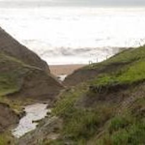
Set on the east coast of the Isle of Wight Luccombe Bay is approximately halfway between Shanklin and Ventnor. Despite this, the main road between these two coastal towns runs some way inland and the only lane down to the bay is private. There is however a footpath that runs down to Luccombe Chine where you can just about scramble down an old landslip onto the beach (although more recent landslips may have made this more difficult).
On a sunny, summer’s morning, when the tide is low it is definitely worth making the effort. You will more than likely have this wide stretch of sand to yourself. The sandstone cliffs to the back of the beach have a good covering of vegetation giving the beach something of an undiscovered feel.
Just by Luccombe Chine is a cave which was used by smugglers in days of old. In fact the Customs and Excise set up a watchtower in the nearby Luccombe Chine House to keep an eye on such activities.
Luccombe Bay
Set on the east coast of the Isle of Wight Luccombe Bay is approximately halfway between Shanklin and Ventnor. Despite this, the main road between these two coastal towns runs some way inland and the only lane down to the bay is private. There is however a footpath that runs down to Luccombe Chine where you can just about scramble down an old landslip onto the beach (although more recent landslips may have made this more difficult).
On a sunny, summer’s morning, when the tide is low it is definitely worth making the effort. You will more than likely have this wide stretch of sand to yourself. The sandstone cliffs to the back of the beach have a good covering of vegetation giving the beach something of an undiscovered feel.
Just by Luccombe Chine is a cave which was used by smugglers in days of old. In fact the Customs and Excise set up a watchtower in the nearby Luccombe Chine House to keep an eye on such activities.
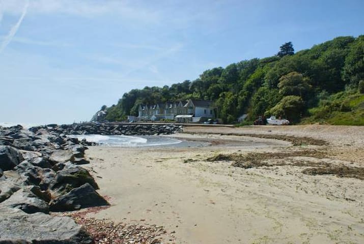
he charming Monks Bay is set on the south coast of the Isle of Wight, just east of the village of Bonchurch. The name refers to the French monks from Lyra Abbey in Normandy who were believed to have landed here.
The beach at Monks Bay is a mix of sand and shingle above the high tide line, but as the tide goes out a large area of sand is revealed. A series of rock breakwaters have been created along the beach to keep the sand where it belongs. To the back of the beach is a promenade beyond which are wooded cliffs.
In the olden days the bay was associated with smuggling. Contraband would be landed here before being ferried inland. These days the only industry is a bit of lobster and crab fishing.
Monks Bay
he charming Monks Bay is set on the south coast of the Isle of Wight, just east of the village of Bonchurch. The name refers to the French monks from Lyra Abbey in Normandy who were believed to have landed here.
The beach at Monks Bay is a mix of sand and shingle above the high tide line, but as the tide goes out a large area of sand is revealed. A series of rock breakwaters have been created along the beach to keep the sand where it belongs. To the back of the beach is a promenade beyond which are wooded cliffs.
In the olden days the bay was associated with smuggling. Contraband would be landed here before being ferried inland. These days the only industry is a bit of lobster and crab fishing.
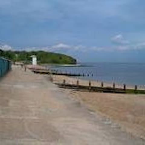
A peaceful sandy beach, backed by dunes and a promenade.
Swimming, walking and birdwatching.
Saint Helens
A peaceful sandy beach, backed by dunes and a promenade.
Swimming, walking and birdwatching.
Located near Bembridge, Seagrove Bay is on the northeast coast of the Isle of Wight. Facing eastwards into the English Channel it is fairly sheltered from both the wind and waves.
Although the beach is pebbly near the shore, at low tide it has plenty of sand which is gently sloping and is ideal for watersports, sandcastles, sunbathing and beach activities. The bay stretches for about 1km (0.6 mile) from Nettlestone Point to Horestone Point and there’s a wooden boardwalk providing access to the seawall.
Seagrove Bay has a Blue Flag award - a guarantee of great water quality and plenty of family-friendly facilities.
Perhaps the only negative point about Seagrove is that at high tide, there beach all but disappears as the water comes up to the seawall marking the high water mark. It’s advisable to check the tide times before visiting.
There’s a small car park nearby and a lane leading down to the beach which has a slipway for boats. You can also park at Seaview and walk around the coast to reach Seagrove Bay. Facilities include toilets.
Seagrove is home to a couple of fairly exclusive hotels and it is not unknown to spot the occasional celebrity here.
9 Einheimische empfehlen
Seagrove Bay
Located near Bembridge, Seagrove Bay is on the northeast coast of the Isle of Wight. Facing eastwards into the English Channel it is fairly sheltered from both the wind and waves.
Although the beach is pebbly near the shore, at low tide it has plenty of sand which is gently sloping and is ideal for watersports, sandcastles, sunbathing and beach activities. The bay stretches for about 1km (0.6 mile) from Nettlestone Point to Horestone Point and there’s a wooden boardwalk providing access to the seawall.
Seagrove Bay has a Blue Flag award - a guarantee of great water quality and plenty of family-friendly facilities.
Perhaps the only negative point about Seagrove is that at high tide, there beach all but disappears as the water comes up to the seawall marking the high water mark. It’s advisable to check the tide times before visiting.
There’s a small car park nearby and a lane leading down to the beach which has a slipway for boats. You can also park at Seaview and walk around the coast to reach Seagrove Bay. Facilities include toilets.
Seagrove is home to a couple of fairly exclusive hotels and it is not unknown to spot the occasional celebrity here.
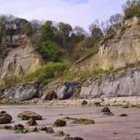
The sand and shingle beach of Whitecliff Bay is situated near the eastern tip of the Isle of Wight. The name comes from the high chalk Culver Cliffs at the southern end of the beach which form part of a site of significant geological interest. These cliffs are also rich in fossils
Whitecliff Bay
The sand and shingle beach of Whitecliff Bay is situated near the eastern tip of the Isle of Wight. The name comes from the high chalk Culver Cliffs at the southern end of the beach which form part of a site of significant geological interest. These cliffs are also rich in fossils